3D data. In London, for example, the British government has published a large number of LIDAR (laser detection and measurement) measurements in London. Fortunately, Andrew Godwin, a San Francisco programmer obsessed with the map, seized on the convenience and used the newly released data to implement his "London Rise" project: a gorgeous and informative 3D printed stereo scale model of central London.
The key point of the project is an Open Data initiative. Under this initiative, the UK Environment Agency publicly released LIDAR (Light Detection and Ranging) data. According to Tiangong, LIDAR technology has existed for decades, and surveyors often use it to accurately capture geographic details (for map production). In these decades, the UK Environment Agency has collected a large amount of geographic data, which is a treasure for the map lovers like Godwin.
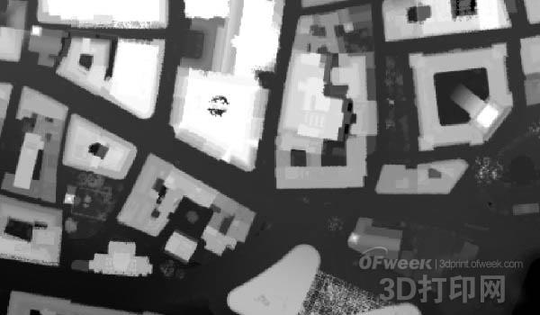
LIDAR data in QGIS
Godwin revealed that he has been obsessed with maps for many years and has been studying 3D map data for a long time. “At the beginning of this year, I finally bought a 3D printer , and then I had a rough plan in a moment – ​​3D printing a real three-dimensional map,†he recalls. After learning about the ongoing data disclosure program in the UK, a brilliant idea came to my mind. Data from most parts of the UK has not yet been made public, but the city centre of London (where Godwin grew up) has already announced that the “Rise of London†was born.
Unfortunately, the LIDAR data is more complicated than originally thought. “The camera below the low-flying aircraft uses a laser ranging system to sample the points, which means that the data you get is actually a series of points per meter,†explains Godwin. “The natural error of laser ranging.†This causes some of the data to float up and down. Therefore, even when a completely flat roof is sampled back, it becomes a series of high and low points. That means you will face two problems: turning the point height into a 3D printer. Identifying things; modifying the model produced from the data so that it doesn't be a jagged thing."
It's not difficult to turn a point height into a 3D model, but it's much harder to make it 3D printable and impeccable. Every detail (in this case, each roof and every wall) needs to be filled with polygons to form a smooth model, which is both time consuming and difficult, and Godwin does not have the necessary skills to achieve these. Therefore, he adopted a more sensible approach. “I retrieved all the data, averaged all the points high to make a lower detail height map, and adjusted the height to a 3m pitch, then applied the adjacent smoothed data to the whole,†recalls Godwin. This also solves another problem. The size of the original file is over 200MB, which takes a long time to open on a regular reader and cannot be sliced.
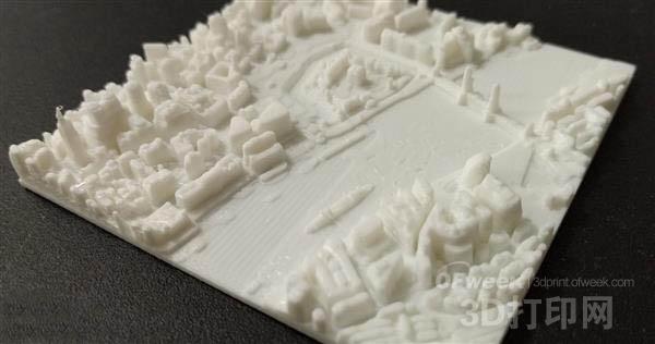
The resulting documents are not perfect, but they are very complete, including London's railway viaducts, bridges, parks and even the underground holes in the ongoing Crossrail railway project. More importantly, the STL file is only 20MB and can be found here on GitHub. But 3D printing is not without challenges, especially Godwin does not have much experience with this. The printer he bought was a Rostock MAX v2 3D printer and it took several days to try out different settings, temperatures and ABS and PLA materials. In the end, he solved the PLA material and took some time to make 3D printing without any problems. “The first 20 porcelain plates have various problems, either there are often drops on the building, or there is a strip of plastic on the model,†Godwin said, but each progress motivates him to move on.
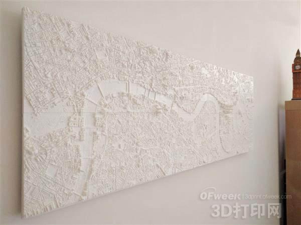
In the end, his successful 3D print of 48 porcelain plates, which were put together to form the heart of London from the Hyde Park in the west to the old house on the Thames by Godwin. “They print size is 7.5×7.5cm, and the final size is 90cm long and 30cm high,†he said. “Depending on the level of detail, it takes 1 to 4 hours to print a 7.5cm tile and print a 15cm. The tiles take 3 to 12 hours. There are two things that are bad about the latter: it limits the amount of time you can print things because the printer needs to be watched by someone while printing; it also means that any printing errors will Destroy a lot of work."
In retrospect, Godwin prefers to use larger tiles. Still, he faces an ambitious 3D printing project that takes weeks to spend most of the night or on weekends. Subsequently, the porcelain plates are attached to a foam board with a strip of wood on the back to provide additional support. “When I prepared all the plates for installation, the main problem I encountered was how to align them. At this point I realized that I should choose a larger size plate, because that means the complexity is reduced by 4 times, and the gap is also Less," he recalls. Some porcelain plates have a slightly rhomboid shape, which leads to several unavoidable gaps.
But the end result is still absolutely amazing, and the details are clearly visible. More importantly, the entire map costs about $200, based on running and material costs. This is a good example of how to use some basic old LIDAR data. "The rise of London" inspired Godwin to apply the same principles to other cities, even San Francisco and Oxford, where he also lived.
Brown Eyebrow Pencil,Grey Eyebrow Pencil,Eyebrow Liner,Waterproof Eyebrow Pencil
Guangzhou Bijiang Cosmetics Co., Ltd. , https://www.bijiangcosmetics.com